
Today I drove 136 miles traveling from Coos Bay, Oregon to Lincoln City, Oregon.

It covers today as well as yesterday and tomorrow here on the Oregon Coast. Today's activities are seen at 1:15:50-2:27:28 in this video. (Don't like long videos? Click |
|
Hello Friends and Family, I set out very early this morning, just after sunrise. All my stops today were looking out into the Pacific Ocean and I didn't want to be looking into the sun so I hit the road early. I set out from my hotel in Coos Bay. I crossed the Suislaw River Bridge in Florence, Oregon. It is a bascule bridge that spans the Siuslaw River on U.S. 101. As is the case with most major bridges on the Oregon coast, it was designed by Conde McCullough.  Heceta Head is a headland that stands 1000 feet above the Pacific Ocean. The Heceta Head Light is located on its south side. Heceta Head is named after the Basque explorer under Spanish Commission, Bruno de Heceta, who explored the Pacific Northwest in the 1770s. The headland marks the end of a lower-lying stretch of the coastline to the south dominated by sand dunes. Again I could not get very close to it. The trail up to the lighthouse was too steep for my scooter so this is the best picture I could get. 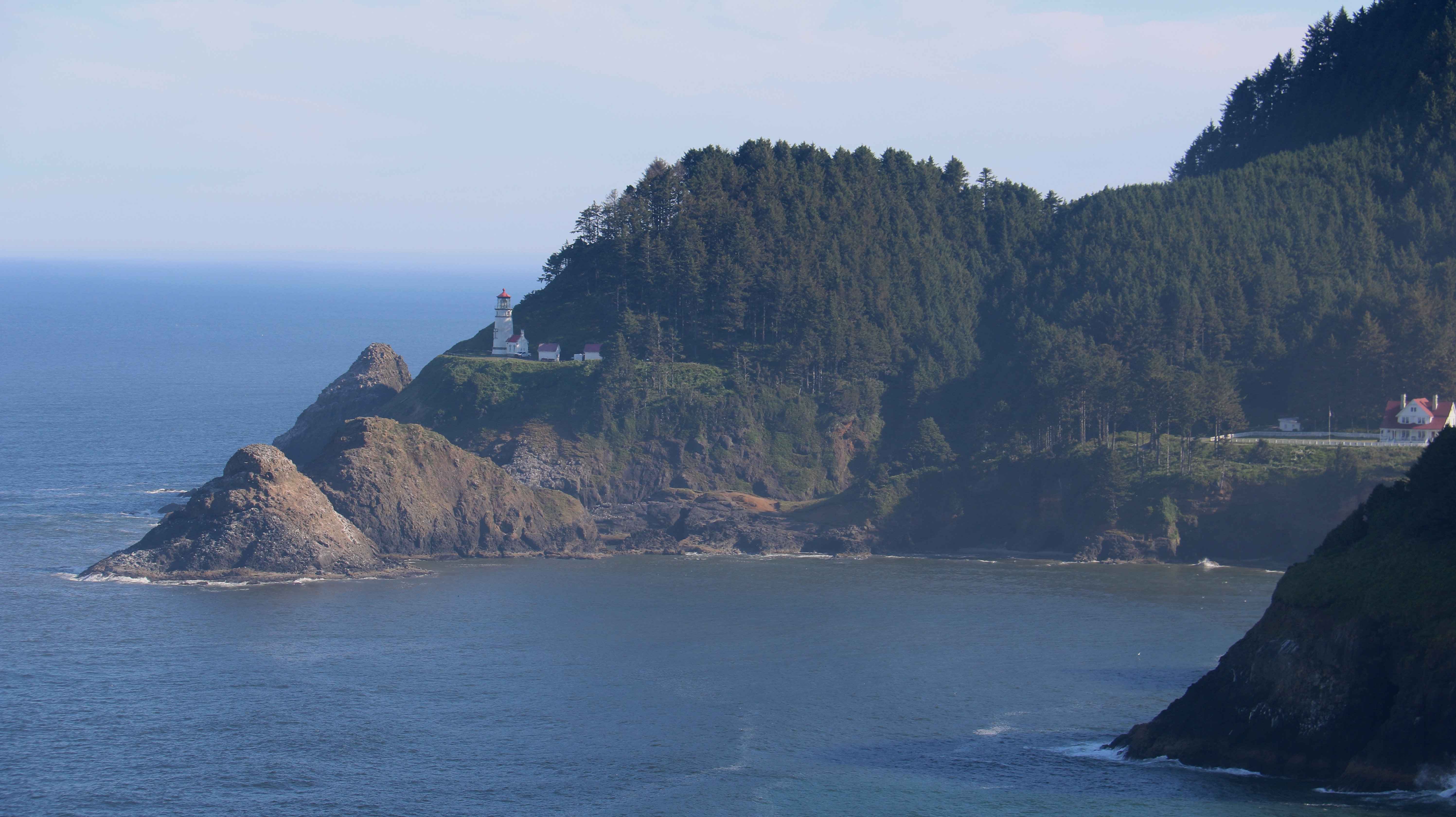 The picture below is from the Cape Perpetua Scenic Area at Cooks Chasm. The area is dominated by tidepools, churns and spouting horns. The Spouting Horn is a salt water fountain driven by the ocean’s power. The Horn puts on its best show at high tide and during winter storms. It must have been low tide this morning because nothing much seemed to be going on.  Next I drove two miles up the side of a hill to the Cape Perpetua Overlook. Towering 800 feet over the protected Marine Garden shoreline, this is the highest viewpoint accessible by car on the Oregon Coast.  The area at the center of the picture below is Cooks Chasm/Spouting Horn/Thor's Well where I just was. At the bottom of the picture is the Devil's Churn which is where I am going next. There was supposedly two whales frolicking out in the water. I asked someone where they were. She said they were near the small boat following them around. I couldn't even see the boat let only the whales. I did see a couple golden eagles flying around. This was my favorite stop of the day.  The Yaquina Bay Lighthouse was built in 1871, soon after the founding of the city of Newport, Oregon. It is located on the north side of Yaquina Bay.  The Yaquina Bay Bridge is an arch bridge that spans Yaquina Bay south of Newport, Oregon. It is one of the most recognizable of the U.S. Route 101 bridges designed by Conde McCullough. The Yaquina Bay Bridge is one of eleven major bridges on the Oregon Coast Highway designed by McCullough.  There were several scenic viewpoints from the scenic Otter Crest Loop just off highway 101.  The view below is just south of Cape Foulweather at the Otter Crest State Scenic Viewpoint. I am glad I decided to stick to the coast on this trip. Inland a few miles east of here temperatures are over 100 degrees. It couldn't have been nicer over here.  At the end of the Otter Crest Loop road as you're heading north is the Ben Jones Bridge Viewpoint. The bridge was built in 1927 as the Rocky Creek Bridge and was designed by Conde McCullogh. Ben Jones is known as the “father of Highway 101.”  Depoe Bay is a small town with a population of 1,398 at the 2010 census. The bay of the same name is a 6-acre harbor that the city promotes as the world's smallest navigable harbor.  And below is the actual harbor.  Since I left so early and accidentally skipped a place on my itinerary, I got to Lincoln City around 2:00. I am staying at the Best Western Plus Landmark Inn. After getting settled I had a late lunch/early dinner. I went to another small local restaurant and again it wasn't much on looks but it was delicious. It was Highway 101 Burger.  I will finish my drive up the Oregon coast tomorrow. That's it for today. Tim |
Most of the original audio track is in tact on this video but occasionally content playing on the radio was removed and replaced with background music. |

Click on the arrow above for tomorrow's adventures.
| TIM'S HOME PAGE SITE INDEX | |||
|---|---|---|---|
| Areas | Description | # of Pages | |
| About Me | Current Picture of me and my home. Information about myself. | 2 | |
| Biography | Pictorial biography of myself. Pictures range from birth to adulthood. | 4 | |
| Family File | Pictures of my family and a little information about them. | 12 | |
| Local Spotlight | Pictures, Links, and Information for Indianapolis, Richmond, Plainfield, and Mooresville, Indiana. | 5 | |
| Tim's Travels | Pictures, videos and travelogs from my travels around the world. | 409 | |
| Vacation Videos | Over 1500 videos from my travels around the world. | 1 | |